Crisscross commuting flows in Beijing suburban neighbourhoods: A call for comprehensive planning
In this blog Wei Zheng and Cecilia Wong, based at the Department of Planning & Environmental Management at the Manchester Urban Institute, described some of the key findings of the ESRC-funded project Eco-Urbanisation: Promoting Sustainable Development in Metropolitan Regions of China. Figures accompanying the text have been mapped by the Eco-urbanisation research team: http://www.eco-urban-china.net
Suburbanisation, collapse of cycling and integrated work unit culture, and complex commuting
Rapid suburbanisation in China’s megacities over the last four decades has altered the traditional home-work balance. In the socialist era, the ‘work unit’ (danwei) was the social organisation shaping workers’ home and work life. Each government department, public institution, or state-own enterprise was a danwei with physical boundaries where offices or factories were co-located with residential buildings, schools, health centres and other amenities. Danwei housing was an integral part of this self-contained model of production and consumption. Early housing reform in the 1980s focused on the privatisation of danwei houses through sales to sitting tenants at discount prices and relocation of state-owned institutions to suburban areas to make way for real estate projects (Wang and Chai, 2009).
Following rapid market reform and economic growth, car ownership has become a symbol of success, together with improved public transport infrastructure, while cycling trips dropped from 63% to 39% between 1986 and 2010 (Poon, 2017). More importantly, policymakers and urban planners did not embrace traditional cycling and integrated work unit culture when planning for urbanisation and redevelopment, which has decoupled workers’ home-work locations and resulted in complex commuting patterns (Feng et al., 2008). According to TomTom’s 2017 Traffic Index, Chongqing (4th), Chengdu (7th) and Beijing (10th) in China are among the world’s most congested cities.
Beijing, as the capital city, has attracted much attention regarding its traffic congestion, long commuting times and air pollution. Since the 1983 Beijing Master Plan, the government has been promoting a polycentric urban form by developing sub-centres and satellite towns to relieve the pressure from the central area. A key running thread of Beijing’s spatial decentralisation has been strategic investment in transport infrastructure to connect the ‘decentralised sites’. According to the 2010 Population Census, the six central urban districts account for 60% of Beijing’s total population and 66% of its total GDP. Both the 1991 and 2004 Master Plans failed to transform Beijing’s spatial structure from a monocentric to a polycentric structure.
Funded by the UK Economic and Social Research Council (ESRC)’s Newton Fund, a three-year research project was carried out by the Manchester Urban Institute to examine the complex commuting patterns in the Beijing Metropolitan Region (BMR). By adopting a spatial perspective, the research team systematically mapped and analysed the commuting dynamics of home-work locations in four neighbourhood groups that have undergone different spatial and temporal urbanisation contexts in the BMR.
Spatial variations in commuting patterns
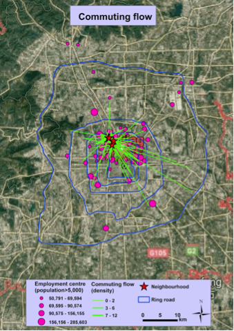
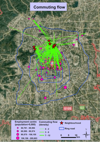
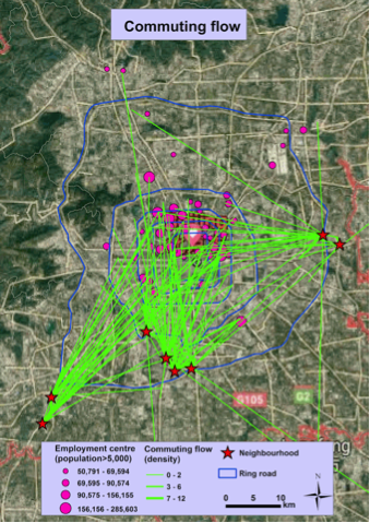
A large scale survey of over 2200 participants was conducted in 19 neighbourhoods (4 inner metropolitan neighbourhoods and 15 outer metropolitan neighbourhoods) of the BMR during May-June 2017. A total of 1,286 questionnaires of those in employment were analysed, of which 917 provided information of their work location for commuting flow analysis. The analysis clearly shows the spatial concentration of employment opportunities in the urban centre and the northern part of Beijing, which contrast sharply to the spatial decentralisation of residential locations to different parts of the BMR (see Zheng, Wong and Qiao, 2019, forthcoming). This spatial mismatch between home and work locations has triggered the lengthening of residents’ commuting distance in the outer metropolitan neighbourhoods with an average of 9.64 km (as the crow flies), especially in the southern and eastern outer metropolitan neighbourhoods. The average commuting distance for the inner metropolitan neighbourhoods is much shorter at 4.33 km (see Figure 1).
The commuting flows of all 19 neighbourhoods are towards the main employment centres located within the 4th ring road and mainly on the east and the northwest of the urban core. Only a few employment centres, both small and large, are found scattering beyond the 5th and 6th ring roads (see Figures 1 – 3). The commuting patterns reveal that the inner metropolitan area and the northern outer metropolitan districts are more spatially integrated than the southern and the eastern outer metropolitan areas (the western districts are mountainous regions). In other words, there exist evident spatial variations in Beijing’s home-work relationships.
The hallmarks of Beijing’s master planning are the massive investment on the extension of transport infrastructure and the decentralisation of employment centres, both of which mainly took place in the northern suburban area. The development alongside the 5th Ring Road in the southern direction was far behind the development in the north. This spatial divide has been accelerated by the strategic decision to locate the Olympic zone in the already advantageous northern districts, especially Haidian and Chaoyang. During 2003 to 2008, 318 km of municipal roads and 148.5 km of metro lines were built in the Olympic Park area, which was three times the capacity of the pre-Olympic era. The northern districts thus continue to be the centre of job opportunities and residents in the nearby suburbs have benefitted from such geographical proximity. This is reflected in the shorter commuting distances of the outer (north) neighbourhoods than their counterparts in the east and the south. The northern region also enjoys higher housing prices (Zou et al., 2015).
The findings from our survey suggest that commuting distance is highly related to commuting mode with the longest journeys by metro, followed by car/taxi. Since the distribution of the metro network is rather uneven, with sparse distribution and density beyond the 5th ring road as well as spatial variations, for long distance commuting, the metro is a major travel mode for the residents in the northern outer metropolitan neighbourhoods to avoid traffic congestion which means that they have to rely heavily on the metro network. However, for neighbourhoods without good metro access in the southern and eastern outer metropolitan area, residents have to use private cars or buses. More importantly, the public transport has met many challenges as ‘long waiting times’, ‘too crowded’ and ‘poor network coverage’ are frequently mentioned by the survey respondents.
Spatial decentralisation without comprehensive planning
Since residents’ commute is a coherent product of their self-selections and compromises, driven by various factors such as socio-economic attributes, personal preferences and institutional factors, they tend to triangulate different factors and make balanced decisions to maximise their utilities. In order to promote sustainable urban development, the government has to play a key role in herding their decisions towards a more sustainable pathway. In a nutshell, infrastructure planning is critical in shaping the provision of public transport access across different parts of the BMR, which in turn affect residents’ access to job opportunities. However, their commuting needs will not abate if the suburbanisation of residential development continues. The crux is therefore to have integrative spatial planning to take into account the locations of employment centres, public services provision and sustainable public transport for future residential development. Unfortunately, reality has a way of falling short of the ideal! As explained by a senior planner in Beijing, industrial parks and residential neighbourhoods were decentralised to some locations with basic infrastructure for rapid turnover and efficiency gain, which meant that the quality of infrastructure and public services did not catch up with the speed of real estate development.
Under UN Habitat III’s New Urban Agenda and China’s own National New Urbanisation Plan, there is a strong impetus to move towards a ‘new type of urbanisation’ that is ecologically sustainable and human-centred (State Council, 2014). A progressive planning agenda is thus needed to move towards quality-oriented and human-centred approaches rather than solely focusing on efficiency and GDP growth. The establishment of the new Ministry of Natural Resources and the recent change on planning responsibilities in China signifies the state’s determination to develop an integrative spatial planning strategy. The delivery of new planning policies and initiatives will no doubt face major challenges at different levels of government, though they will also provide incentives to achieve sustainable urban development. Therefore, it is crucial to monitor how different planning issues at multiple spatial scales can be integrated into a coherent framework for strategic spatial thinking.
References
Eco-urbanisation (2019) Commuting Flows of Selected Neighbourhoods in Beijing. Available at: http://www.eco-urban-china.net/
State Council (2014) National New Urbanisation Plan (2014-2020). Beijing: State Council.
Poon, L. (2017) Rebuilding the ‘Kingdom of Bicycles’. In: Citylab. Available at:
https://www.citylab.com/transportation/2017/04/bikeshare-save-biking-in-china/521181/
Wang, D. and Chai, Y. (2009) The jobs–housing relationship and commuting in Beijing, China: the legacy of Danwei. Journal of Transport Geography, 17(1), pp.30-38.
Zheng, W., Wong, C. and Qiao, M. (2019) Socio-spatial variations in commuting patterns in suburban Beijing. Built Environment. forthcoming.
Zou, Y., Mason, R. and Zhong, R. (2015) Modeling the polycentric evolution of post-Olympic Beijing: An empirical analysis of land prices and development intensity. Urban Geography, 36(5), pp.735-756.