Measuring mobility and segregation in metropolitan London and São Paulo
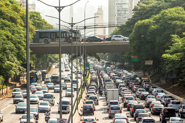
Our ESRC project with the University of Sao Paulo and Instituto Nacional de Pesquisas Espaciais (INPE), launched on 26-27 November in Sao Paulo at the Center for Metropolitan Studies, aims to map the impacts of transportation systems on inequality in two of the world’s largest megacities. By measuring and modelling social and spatial segregation in the metro areas of London and São Paulo, which are roughly comparable in size with populations of 15 to 20 million, we hope to develop quantitative comparisons of the dynamics of exclusion in with a strong focus on transport accessibility.
The mission of the project, RESOLUTION: REsilient Systems fOr Land Use TransportatION, is to derive measures that show resilience as well as vulnerability with respect to social and spatial segregation, with a focus on transport and movement. As cities get bigger, people travel longer and commute times in São Paulo tend to be longer than London, but the quality of the experience differs. In São Paulo the spatial structure of the city locks people out in ways that are different from areas of poor accessibility in London. We intend to measure this kind of exclusion using access of different groups to different kinds of employment, and go beyond this to deal with access to other facilities such as hospitals, schools and related welfare (or lack of it). Our effort is to see where we might identify pressure points that reveal vulnerability and points where we might engender some resilience.
So far we have not completely worked out the sets of measures that we will work with, but we consider local indicators of spatial association, entropy measures, distributions of uneven patterns ranging from income distributions to distributions of density – all these will be employed, following some of those we worked with in our previous modelling projects (accessibility indices) and diversity indices worked on by Chen Zhong in our recent Urban Studies paper. We have also pencilled in that we will explore new ideas about accessibility and segregation from agent based model of transport, and our aim is still to build simple ABMs reflecting household choices with respect to travel for São Paulo and London. A key concern of the project will be focused around segregation – Flavia Feitosa, one of the team members based at the Center for Engineering, Modeling and Applied Social Sciences, has done a lot of work already on São Paulo with respect to modelling segregation using ABMs and we will follow her lead.
Last but not least, we are establishing two web portals – one for London and then an equivalent one for São Paulo – so that we can compare data but also provide a resource that others might use to explore the same data that we will assemble and work with. This also provides an initial focus on how we might take the research forward. Although we think there is reasonable comparability of data between the two cities at similar levels of spatial aggregation, until we assemble the data and develop the portals we will not know of the problems that are likely to arise.
RESOLUTION: REsilient Systems fOr Land Use TransportatION is a collaborative research project between British and Brazilian academics, jointly funded by the ESRC and São Paulo Research Foundation. More information about the project can be found here. This post originally appeared in modified form on Michael Batty’s personal webpage, where an overview of his research and other writings can also be found.